Death Valley, Dec 25th – 27th 2009.
Death Valley is a different kind of National Park, in that its not going to overload your senses with beautiful scenery like Yosemite or colors like Yellow Stone, but it is scenic in its own right. Between arid and lifeless extends of badlands(wastelands), is an extensive collection of topography, marble, lose clay, sedimentary rock, ignitions rock, salt flats, sand dunes and even an oasis! And the sunrises…oh the sunrises!! To summarize, Death valley may not be the most beautiful park but it surely is extraordinary; even beautiful in its own subtle way.
Some Notes: Death valley is best enjoyed in a 4×4 SUV. Coming here in a Sedan is not smart. One can get around in a sedan but the make sure it’s rented. Driving one personal car is foolish. Needless to say, I was foolish.
Day 1:__________________________
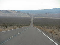 We started for Death Valley at 8am from Irvine, reached Baker by 11am and Shoshone (Show-show-Ney) by 12pm via route 127. Then we took route 178 to Badwater. Initially, the drive along 127 and 178 was lonely. We were the only car for miles in each direction. The fact that we’d be by ourselves if our car broke down, constantly played on our minds. But all that changed when we reached Badwater.
Suddenly, there were a lot of cars and a lot of people there (even desis!!) I am desi so I shouldn’t complain but there were saree’s there, oh and a lot of Asians, were are the goras!!
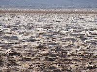 Badwater is the lowest point in continental USA. There is even a sign there marking sea level. We walked into the Badwater basin, a nice easy hike of a mile or two. The top 3-4 inches of the surface is just ripped open by the salt; giving it a scaled look. There are miles after miles of this scaling.

Then a few miles down the road came the turn for ‘Natural Bridge’. The 1.5mile road to the parking area is unpaved and naturally uneven. The car, tires and suspension took a beating. The Natural bridge, as the name suggests is a arch formed out of rock and mud. That isn’t the only attraction there. There are other formations there formed by storm water (Flashfloods). It’s actually an easy hike of 1.5 miles but the gravel floor makes it slightly difficult.
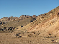 Next, we turned into a one-way street called, “Artist’s Drive”. The rock formations in this part of the mountains have pink, green, blue, red, white and orange colors. What’s most peculiar is not the colors themselves but that they are concentrated in small patches. While the red, pink and white are abundant, blue and green just pop-out in a few places, as if to ooze out of the mountain side. The most spectacular place this happens is the Artist’s pallet. I guess every major national park has one.
By now it was 4pm, the Sun had almost set and we had to reach Furnace Creek to visit the Visitor Center for maps and pay Park Fees. Death Valley, is the only National Park I have visited that does not have a ranger station or Visitor center at park entrance. The Visitor Center is right in the heart of the park.
Now began the scariest part of our trip. It was getting dark and we had to reach our hotel in Tacome (just south of Shoshone). It was pitch dark, few cars on the road and we didn’t have a clear idea where the hotel was exactly. Google maps had given an approx location
 but GPS couldn’t find it. We tried another motel on the way but it had no vacancy. We asked at the motel and at a gas station in Shoshone but no one knew about our hotel. So basically, we were driving in the dark, figuratively and literally. All worst case scenarios of car breaking down, tire blowouts & our fate following that came to mind. Finally, we came to the intersection where Google said we should be turning, so we did. The first 5 miles seemed to go no where, actually, it looked like we were headed deep into a canyon. Our hearts were in our mouths. We came up to a dimly lit house, may be 2. But we dare not knock on their doors….sixth amendment. Enough said. I looked to the heavens and we decided to continue a few miles along the road and there it was!! In the middle of know where, on a crumbling road, deep in canyon our $100 room @ Cynthia’s!!!
Well, at least the room was good, clean comfortable! Cordial, knowledge able staff. Then we went off to have our Christmas dinner at China ranch 3 miles from the hotel but I’ll save that scary story for a few round of drinks.
Day 2:________________________
Today we saw two canyons, two Vista points and a ghost town.  We started our day at the crack of dawn, to see sunrise at Zebriski Point. Driving at 90 miles/hr we reached Zebriski point at 6:45am. Someone mentioned to us, “Zebriski point looks beautiful at Sunrise but its ethereal just after”. He wasn’t exaggerating. The early Sun hitting the mountains, badwater and near by ‘stripped’ mountains brings out unbelievable colors. It’s a popular spot for professional photographers.
Next we travelled 20 miles to Dante’s View. It is the highest point reachable by car at Death Valley.  The enormity of the basin can be judged only from this point. The vastness of salt deposits and weird ‘crop circle’ like salt deposits in the basin are some of the breathtaking view from here. When we went up at 9am, it was freezing cold. Temp close to 0C, wind sheer made it unbearable further. Still we did a small hike along the mountain edge to the farthest point in the south to get a straight line view of the salt basin. This is also a popular sunrise spot. I think this is where I caught my cold ! Next we headed to Furnance Creek for breakfast and since we weren’t coming back this way, we did some souvenir shopping in the gift shop.
Our next stop was ‘GoldenCanyon’. This canyon is formed by flash floods washes –
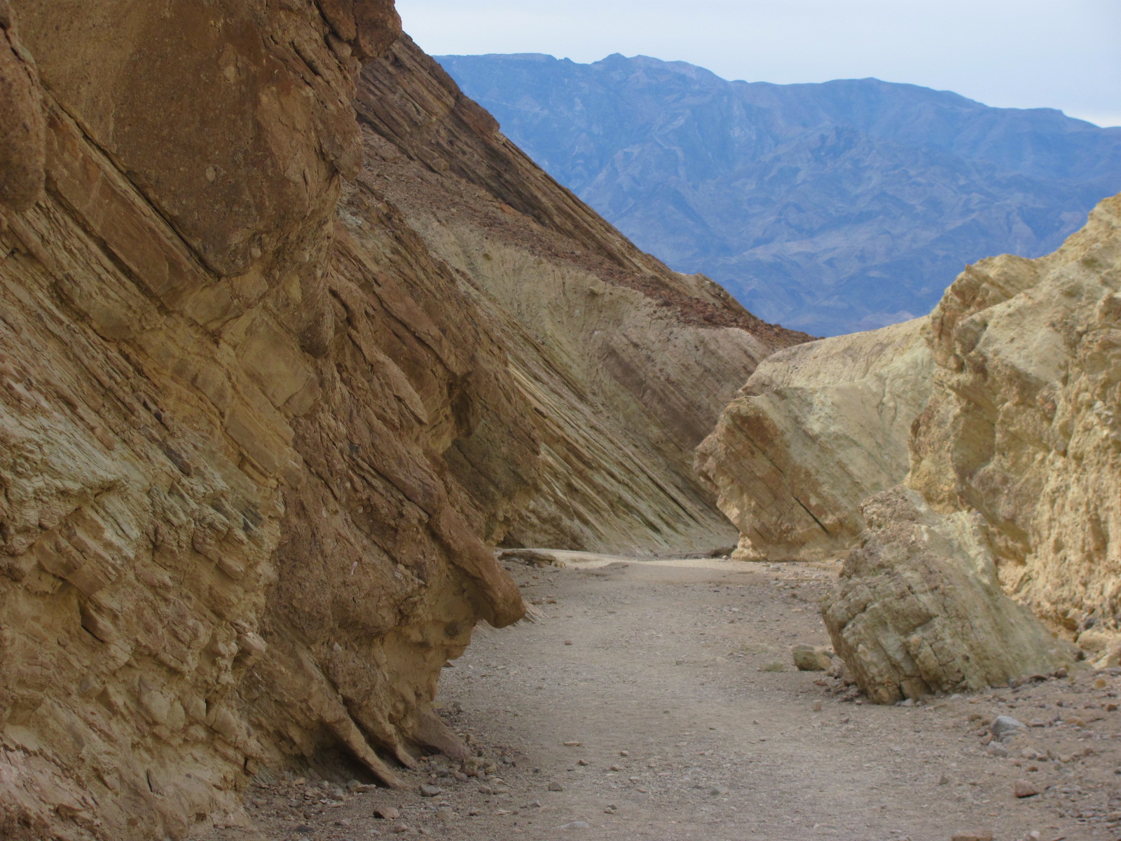
floods eroding the canyon walls. The canyon once had a road leading into it, but a flash flood washed away the entire road and then some. An easy walk (easier than NaturalBridge since the gravel covered ground was more compact) goes through the winding canyon. Along the way are markers with interesting information on the geology on display here. Did you GoldenCanyon was once the end of a vast lake? Undisturbed geological evidence is clearly visible on the canyon walls. This 1.5 mile hike ends in the ‘Red Cathedral’ – a 200 ft high wall of cathedral like red rocks – rising completely out of place from a golden/yellowish canyon. We took some side trails along washes of smaller tributaries.

From one canyon to the next – MosiacCanyon. It is named so because
it looks like pieces of tiles cemented together. But the more interesting thing here is the marble, its colors, its textures and patterns. The trail into mosaic canyon is about 3 miles but the first 1 mile is the most interesting one. After taking a few pictures we stopped at a point to experience the silence that prevails in Death Valley. In most places in the Death Valley, if there are no people around, there is an eerily silence – pin drop silence!
By the time we were done here it was nearly 4pm. We wanted to see
 sunset on Sand dunes but it was cloudy and no chance of a proper sunset. So we headed back to our hotel in Beatty, Nevada. We didn’t want to experience the darkness of the night before. On the way, we stopped at a ghost town, Rhyolite. In the fading light, it was hard to fathom that this town was once a busy place. The town is not spectacular or well maintained but gives some idea of the time when Death Valley was an important mining area.
Finally we retired for the night in our hotel – Atomic Inn. Named so, because the contractor who worked on the bombs dropped on Hiroshima and Nagasaki stayed here. Beatty is a bigger town that Tacopa, it has a restaurant – actually 3 & cell phone coverage …. We felt connected to the world again.
Day 3:____________________________
Day 3 began with a comedy of errors. My iPhone was out of sync with network time after being off for a while. Somehow it was 2 hours behind. So when I set the alarm for 5am, it actually went off at 3am !! Not surprising then, we reached the Sand Dunes in time to see the sun rise. No need for unnecessary speeding.
 Death valley is called the sunrise-sunset park for a reason.While, the rising sun brought out beautiful colors at Zebriski’s point, at Sand Dunes the beauty lies in the shadows it produces – bright on one side and dark of the other. You can trace how the sun rays travel across the landscape. It’s really amazing. Not to be missed!! We sat on the sand dune for an hour just soaking up the amazing display and once again experiencing the silence. Our plan were to go to Scotty’s Castle after this but we decided to turn back home as my cold was getting worse.

We did however, make one stop at ‘China Ranch’.We had been to this
place at night on day 1 and it looked ghastly then. During the day, the road leading up to the ranch still gave me the chills from memory. The ranch is actually oasis in the desert. The ranch is actually a dates plantation. They have the best ‘Dates Milk Shake’. Another, ‘must-do’ thing in Death Valley. The plantation is open to the public to walk about. There is a small museum on the history of the ranch, a gift shop and even some trails.
With our tummy’s full on copious amounts of dates and dates milk shake we returned home!
by Kartik Gupte

Sanjay U-watch….Dear Kartik<very nice presentation and story writing skill; no need to go there again… RegardsPrakash Gadgil5108255580
Hi what an adventure !my whole family has done it several times in several countriesgood to know more marathis are leading a this kinda risky life.Last I remember my son abhiram getting lost near Elpaso Tx with trail maps, GPS, 4by4 jeep, two flat wheels,and mountain lions hollowing.He was rescued with the help of a helicopter,and rescue team of 3 emergency vehicles.I used to get nightmares if the state of Texas is going to send me a rescue bill or what…Not till nowwow happy adventures !!
Great Story!